This week we had our first big adventure leaving the reserve, and summited Mt. Chirripo! Chirripo is Costa Rica's biggest mountain, and the second largest in Central America, at 12,530 feet. I think that that makes it the tallest mountain I've ever made it to the top of (though I have been that high before, both in Colorado and Ecuador). It was quite the hike, but well worth it.
Our first hurdle was getting the necessary permits. Chirripo is located in a national park (the one that Cloudbridge abuts), and so a limited number of passes are sold to go in each day. Because we wanted to spend the night at base camp 3/4 of the way up the mountain, we needed permits to stay, as well as simply get in. 15 permits for each day are sold by phone, but these tend to be reserved months in advance. However, they also reserve 10 tickets/day for people who show up at the office and want to climb the next day. The office being a little downhill of San Gerardo (about an hours walk), this was the option for us. So, after canvassing the other volunteers and rounding up two others crazy enough to want to hike with us, we arrived at the office on Friday at 12:05 on our way back from San Isidro in the reserve's truck. We were waved away - the office had closed at 12 for lunch and wouldn't reopen until 1. So we patiently got lunch in San Gerardo before returning by car to the office, where we learned that there were two spots available for hiking up Saturday, but certainly not 4. We came home, and decided to head down in the morning to see if we could go up Sunday. Arriving at 10 on Saturday was still pushing it, as Carlos, the friendly parks ranger in charge, informed us that he remembered us, but we were very late! He'd already sold a lot of tickets that day. Luckily, we were able to get our 4. That night we packed, trying to keep our backpacks as light as possible while also bringing all of our warm clothes. We'd heard the base camp was freezing.
The Chirripo Trail actually begins a bit before Cloudbridge, at something like 4,987, but it later runs through the top corner of Cloudbridge, and there are trails in the reserve that meet up with it. So, when we started at 5:30 AM, we elected to walk out our front door and start heading up, through the reserve rather than down to the trailhead. This was probably a good decision, but definitely made our first hour steeper than it had to be. But, while still in Cloudbridge we saw another Black-speckled Palm Pit-viper! And got pictures of it!


The hike to base camp is 14.5 km (9 miles), with an elevation gain of about 6,000 feet. We took frequent breaks, and it ended up taking us 8 hours. The first 2/3 or so were in cloud forest, where we hiked through some big old oaks and lots of Spanish Moss. Eventually we came out of the trees into the alpine zone. The area we hiked through had burned, so there were some skeletal trees, but the vegetation was decidedly alpine, and it was hard to imagine what it had been like with trees. I saw indian paintbrush, lupin, and geraniums that all looked similar to those found in the West, but also lots of unfamiliar plants. As the air got thinner and general exhaustion set in, there were more and more inspirational messages such as this one:

I continued my slow plod up the hill (the boys even waited for me fairly often), and we made it to base camp just as the afternoon rains began. We spent the afternoon resting, and even though lights out wasn't until 8, we were in bed by 6:45, preparing to wake up at 3 the next morning.
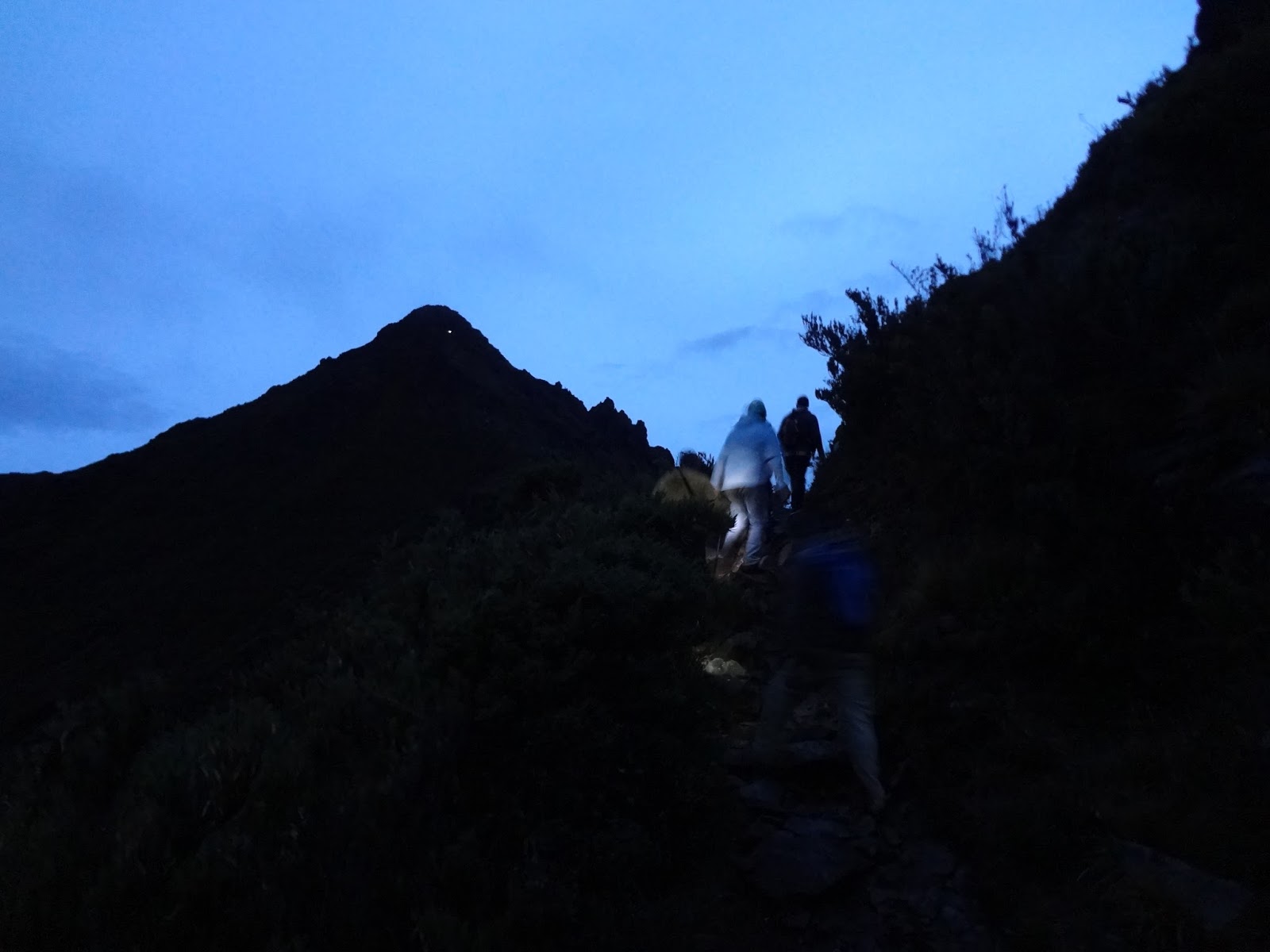
In the morning we had another 5.1 km (~3 miles) and ~1,500 feet to climb before getting to the summit, where we hoped to see the sunrise. We almost made it... we were making the final ascent as the sun came up. Here's a picture of Chirripo, where you can see someone's headlamp near the top.
Views from the top were great (though we didn't see both oceans), and we sent you all a SPOT at 5:40!

Our first hurdle was getting the necessary permits. Chirripo is located in a national park (the one that Cloudbridge abuts), and so a limited number of passes are sold to go in each day. Because we wanted to spend the night at base camp 3/4 of the way up the mountain, we needed permits to stay, as well as simply get in. 15 permits for each day are sold by phone, but these tend to be reserved months in advance. However, they also reserve 10 tickets/day for people who show up at the office and want to climb the next day. The office being a little downhill of San Gerardo (about an hours walk), this was the option for us. So, after canvassing the other volunteers and rounding up two others crazy enough to want to hike with us, we arrived at the office on Friday at 12:05 on our way back from San Isidro in the reserve's truck. We were waved away - the office had closed at 12 for lunch and wouldn't reopen until 1. So we patiently got lunch in San Gerardo before returning by car to the office, where we learned that there were two spots available for hiking up Saturday, but certainly not 4. We came home, and decided to head down in the morning to see if we could go up Sunday. Arriving at 10 on Saturday was still pushing it, as Carlos, the friendly parks ranger in charge, informed us that he remembered us, but we were very late! He'd already sold a lot of tickets that day. Luckily, we were able to get our 4. That night we packed, trying to keep our backpacks as light as possible while also bringing all of our warm clothes. We'd heard the base camp was freezing.
The Chirripo Trail actually begins a bit before Cloudbridge, at something like 4,987, but it later runs through the top corner of Cloudbridge, and there are trails in the reserve that meet up with it. So, when we started at 5:30 AM, we elected to walk out our front door and start heading up, through the reserve rather than down to the trailhead. This was probably a good decision, but definitely made our first hour steeper than it had to be. But, while still in Cloudbridge we saw another Black-speckled Palm Pit-viper! And got pictures of it!
The trail itself was a sloppy mess by the time we reached it. While we are only at the beginning of the rainy season, the porters who can be hired to take your gear up the mountain use horses, which churn everything up. The soil here has a lot of clay in it, so it was slippery going at first.
The hike to base camp is 14.5 km (9 miles), with an elevation gain of about 6,000 feet. We took frequent breaks, and it ended up taking us 8 hours. The first 2/3 or so were in cloud forest, where we hiked through some big old oaks and lots of Spanish Moss. Eventually we came out of the trees into the alpine zone. The area we hiked through had burned, so there were some skeletal trees, but the vegetation was decidedly alpine, and it was hard to imagine what it had been like with trees. I saw indian paintbrush, lupin, and geraniums that all looked similar to those found in the West, but also lots of unfamiliar plants. As the air got thinner and general exhaustion set in, there were more and more inspirational messages such as this one:
I continued my slow plod up the hill (the boys even waited for me fairly often), and we made it to base camp just as the afternoon rains began. We spent the afternoon resting, and even though lights out wasn't until 8, we were in bed by 6:45, preparing to wake up at 3 the next morning.
In the morning we had another 5.1 km (~3 miles) and ~1,500 feet to climb before getting to the summit, where we hoped to see the sunrise. We almost made it... we were making the final ascent as the sun came up. Here's a picture of Chirripo, where you can see someone's headlamp near the top.
Views from the top were great (though we didn't see both oceans), and we sent you all a SPOT at 5:40!
We arrived back at base at 7:45 (4 hours and 6 miles later), where we picked up our packs and headed down the mountain. An exhausting trip, but we're definitely glad we did it!
I'll be putting an album on facebook with more pictures, and will link to it here when I do. Update: Here's the link! Also, notice that we put an option on the right to subscribe by email! Now you don't have to check back all the time if you don't want to :)
WaHooo!!! Congratulations!! What an accomplishment! That trail looked horrible at first! And I'm not so excited about you running across pit vipers!
ReplyDeleteNOT A HIKE i WANT TO TAKE...BUT VERY EXCITING TO READ ABOUT IT :) Love the viper pix!
ReplyDelete